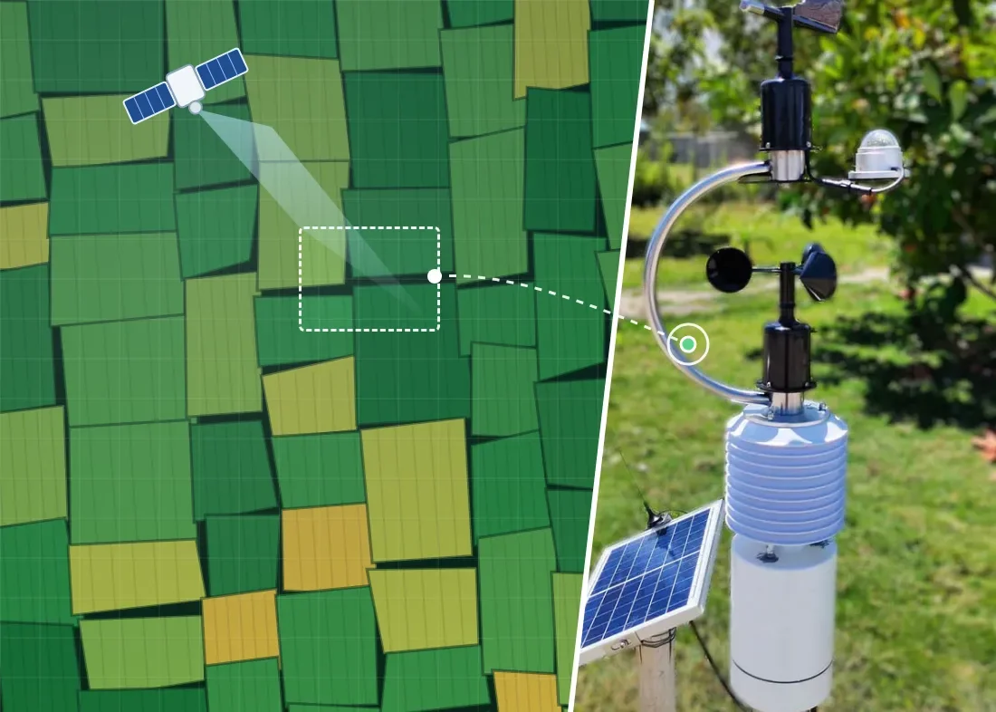
Article Summary | Open a satellite platform and crop vigour across the whole farm is clear at a glance, so do you still need a weather station in the field? In fact, satellite remote sensing and a field microclimate weather station look at two different things. A satellite photographs from above at regular intervals, which suits comparing crop trends over large areas. A field station is placed in the ground and measures continuously, which suits tracking real-time changes in rain, soil and temperature, and notifying you and linking equipment when values are abnormal. This article explains how each works and what its characteristics are, which sites each suits, and how to combine the two, so farm management does not have to be an either-or choice.
1. Two Ways to Look at a Field: From Above and in the Field
To make decisions with data, a farm first has to obtain data. The two most common ways today are satellite remote sensing, where satellites photograph the Earth's surface from space and crop conditions are analysed from the images, and field weather stations, where sensors are installed in the field to measure air, rainfall and soil directly.
The two are often compared as if you can only pick one. But they answer different questions: satellites answer “where across the whole farm is it different?”, and field stations answer “how is it right here, right now?”. Once you are clear about which kind of problem you are trying to solve, choosing becomes much easier.
2. What Satellite Remote Sensing Does Well
The optical satellites commonly used in agriculture record the visible and near-infrared light that crops reflect. Healthy leaves absorb red light and reflect near-infrared light, and the Normalized Difference Vegetation Index (NDVI) calculated from these two bands shows how lush the crops are. The U.S. Geological Survey (USGS) notes that NDVI is one of the most commonly used vegetation indices.
Take the European Space Agency (ESA)'s Sentinel-2 satellites as an example: imagery resolution is as fine as 10 metres, and a single pass covers a swath about 290 kilometres wide. This brings several clear advantages:
- Wide coverage: See dozens or hundreds of fields at once, which suits agribusinesses, cooperatives and regional monitoring.
- No site visit needed: Outline your fields on a computer and view them, which suits fields scattered in different places.
- Look back in time: Satellites accumulate imagery over the long term, so you can compare crop vigour in the same period this year and in past years.
- Spot differences: Which part of a single field is growing weaker is easy to see in the imagery.
3. Three Characteristics to Know Before Using Satellite Data
A satellite's characteristics come from how it observes. Understanding them lets you use the data in the right places:
- It images only when it passes over: Satellites follow fixed orbits and can only image a place when they pass over it. The two Sentinel-2 satellites together image the same spot about every 5 days near the equator, always at around 10:30 local morning time. Some commercial constellations can image land every day, but that is usually still only one time point per day.
- Optical imagery is blocked by clouds: Optical satellites rely on reflected light, so when clouds cover the ground it cannot be seen. A study cited by NASA indicates that about two-thirds of the Earth's surface is normally covered by clouds. In rainy seasons or cloudy regions, several passes in a row may fail to produce a clear image. Radar satellites can penetrate clouds, but what they can analyse differs from what optical satellites can.
- They see surfaces and block averages: Satellites see leaf surfaces and the ground surface. NASA's soil moisture satellite SMAP, for example, measures the top roughly 5 centimetres of soil as an average over 9-kilometer grid cells, which suits judging regional wetness and dryness, not a single field. Soil pH and electrical conductivity, or dissolved oxygen in a fish pond, still have to be measured directly with probes.
4. What Field Weather Stations Do Well
A field weather station is a set of sensors installed in the field, measuring actual values for “this location, at this time”:
- Continuous recording: It measures by day, at night, on overcast days and in the rain, so changes within a few hours, such as early-morning cold or an afternoon downpour, are not missed.
- Instant notification: When a value crosses the threshold you set, your phone is notified right away, with no need to wait for the next analysis.
- Direct measurement: Rainfall, wind speed, soil temperature, moisture, electrical conductivity (EC) and pH are all values measured directly by sensors.
- Equipment linkage: Paired with control equipment, it can open the water automatically when the soil is too dry, turning data directly into action.
Field stations have limits too: one station represents conditions nearby, so large fields or fields with big differences in terrain need more points, and installation and maintenance costs rise accordingly.
5. Differences at a Glance
| Comparison Item | Satellite Remote Sensing | Field Weather Station |
|---|---|---|
| Observation method | Images of the Earth's surface captured from space | Sensors installed in the field measure directly |
| Update frequency | Depends on the satellite's pass cycle; optical imagery is affected by cloud cover | Continuous measurement; sampling interval is adjustable |
| Data it does best | Vegetation indices, differences in crop vigour, large-area changes | Rainfall, temperature and humidity, wind speed, soil temperature and moisture, EC, pH |
| Coverage | Large areas, many fields | Near the placement point |
| Instant alerts | Depends on when the imagery is updated | Notifies you when a value crosses the threshold |
| Automatic control | Needs separate on-site equipment | Can link directly to control equipment |
| Getting started | Outline your fields online | Install sensors in the field |
6. How to Choose: Start from the Problem You Need to Solve
- You have many fields over a large area and want to know which part is growing worse: Satellite remote sensing is a good starting point.
- You need to guard against frost or heavy rain, or track real-time conditions in a greenhouse or orchard: You need the continuous measurement and instant notification of field stations.
- You want irrigation, fans or shading to switch on and off automatically based on data: You need field stations paired with control equipment.
- You need soil EC, pH or water quality data: You need probes that make direct contact with the soil or water.
- All of the above: Use both together.
7. How to Combine Them: Satellites Show the Whole Farm; Field Stations Show What Is Happening Right Now
Satellites and field stations do not conflict. Used together, each has its own role:
Satellites find the areas that need attention → field stations confirm what is happening on site right now → control equipment handles it automatically
In practice: first use satellite imagery to find areas where crop vigour differs, then place field stations at representative locations as ground reference points. When the imagery shows a particular area is weak, you can compare that area's soil moisture and rainfall to judge whether water shortage is the cause. Between two satellite images, field stations keep monitoring and notify you immediately when something is abnormal. If both sets of data can be brought into one system, managers do not have to switch between two platforms.
8. The YenProtek Approach: Let Fields Report for Themselves and Equipment Act for Itself
FarmerPack is a solar-powered, modular field microclimate weather station developed in-house by YenProtek. Its 19 sensor modules can be selected to suit your needs, and the sampling interval can be set anywhere from 1 minute to 24 hours. When the network is unstable, data is stored on a memory card first and uploaded automatically once the connection returns. When a value is abnormal, notifications can be sent by app push, LINE, SMS or email.
Paired with the Smart Control Box, you can set rules on your phone such as “when soil moisture falls below the set value, open the water valve”, so existing pumps, solenoid valves and fans start and stop based on data. If the network goes down, the control box keeps running on the settings it last downloaded from the cloud.
YenProtek's cloud platform can also provide an API and MCP (an open standard that lets AI assistants read external data) to connect field data to an existing farm management system or satellite remote sensing platform, so ground and satellite data can be used together. To see the platform in action first, you are welcome to fill in the demo account request form, and we will get in touch with you.
FAQ | Common Questions About Satellite Remote Sensing and Field Weather Stations
Q1: If I can view my fields by satellite, do I still need to install sensors?
It depends on what you need. If you only want to compare crop vigour across a large area, satellites are a good fit. If you need instant alerts, direct measurements such as soil EC and pH, or irrigation that runs automatically on data, you need field sensors. The two do different jobs and can be used together.
Q2: How often does satellite remote sensing update?
It depends on the satellite. For Sentinel-2, the two satellites together image the same spot about every 5 days near the equator; some commercial constellations can image daily. Optical imagery cannot see the ground through clouds, so the images you can actually use are fewer than the number of captures.
Q3: Can satellites measure soil moisture?
They can estimate it. Satellites can estimate soil moisture from radar or spectral signals, which suits regional trends, but the values are surface or block averages. To know the actual moisture of a particular field at a particular depth, or to measure soil EC and pH, you still need sensors placed in the soil.
Q4: How many field weather stations do I need?
It depends on field size, terrain and how the crops are zoned. One station represents conditions near where it is placed, so for fields with large differences in terrain or soil, we recommend placing one in each block with different conditions. You can also use satellite imagery first to find the areas with larger differences, and then decide where to place stations.
Q5: Can satellite data and field data be in the same system?
Yes, as long as both systems offer open integration interfaces. YenProtek's cloud platform can provide an API and MCP to connect field data from devices such as FarmerPack to an existing system; the actual approach is assessed based on the interfaces the other system opens up.
References and Further Reading
References:
- ESA:Sentinel-2 Facts and figures
- Copernicus SentiWiki:Sentinel-2 Mission
- NASA:Cloudy Earth
- ESA:Sentinel-1 seeing through clouds
- NASA:SMAP's First High-Resolution Global Soil Moisture Map
- USGS:NDVI, the Foundation for Remote Sensing Phenology
- NASA Earthdata:Commercial SmallSat Data Acquisition — Planet
Further reading:
- Beyond Temperature and Humidity: What Agricultural Sensors Are There? A Complete Guide from Soil, Weather and Water Quality to Environmental Monitoring
- What Is an Automatic Sprinkler System? Stop Watering by Feel and Let Irrigation Start and Stop Automatically Based on Conditions
- Do not Rush to Choose Wi-Fi: How to Select IoT Communication Technology? Which Scenarios Suit LoRa, NB-IoT and 4G?
- What Is Precision Agriculture? Low-Cost, Data-Driven Tools That Small Farms Can Use Too
If you are evaluating satellite remote sensing, field microclimate weather stations, or how to use the two together, we welcome you to talk with YenProtek. Based on your site size, crops and management needs, we will help plan a suitable monitoring and control setup.